


Laura Norman works for the USGS (United States Geological Survey), a US science bureau, studying water flow through our rivers and landscapes. There is a slow water movement underway, being spread by permaculture, agroforestry, Natural Sequence Farming and regenerative agriculture, promoted by people like Erica Gies, the author of ‘Water always Wins’, and its essence captured by Brock Dolman’s phrase ‘slow it, sink it, spread it’. Laura Norman has been helping make the impact of slow water more scientific with her hydrological modelling and observational studies, and helping bring these slow water ideas to US governmental agencies.
It is perhaps a surprising idea that putting rocks in streams would have an impact on hydration of land around it, but slowing down flowing waters, can give them a chance to seep into soil and aquifers, and then spread sideways. It is also perhaps unexpected that the creek flow can increase by about a quarter as a result of putting rocks into it. A common assumption is to think the rocks are blocking the water from going to downstream people. But it actually increases the water available to downstream folk, because it reduces peak flow during big storms in the winter, and parcels out that water to flow more in the future - the creeks flow four weeks longer and with more volume into the dry season.
Whats further intriguing, is this simple idea of putting rocks in streams can actually lessen wildfires. This is because the water now has a chance to seep laterally into the floodplains through the soil and aquifers, allowing the plants to be hydrated into the dry season. Its a similar effect to what beaver dams do to the water flow. There are a number of famous photos floating around the internet, of the vegetation in the floodplains around beaver dams being unscathed by fire, while the area around them is burnt.
Norman studies how gabions and check dams, rocky structures that slow the flow of water in our streams, impact how water flows through other parts of the watershed, how they help farmers deal with droughts and floods, and how it provides us with a more nature-based way of water management.
Here;s our interview (lightly edited):
Alpha: Today I'm excited to have Laura Norman from the USGS, the United States Geological Survey. Welcome.
Laura: Thank you.
Alpha: Cool. What is it that you do with the USGS?
Laura: I am a physical supervisory research physical scientist. I've been working at the USGS Geological Survey since 1998. And I study watershed modeling and all of the components of the water budget related to dryland regions. And so my research has been looking at how people can impact water budget parameters in models and trying to develop scenarios that are beneficial for management. Water budget meaning like the water cycle. So I look at all the components of the water cycle. So everything that comes into a watershed, what happens to the water when it is here and how it leaves.
Alpha: How did you get interested in water and land?
Laura: Well, I am originally from the swamps of Rhode Island. And so I grew up in a wetland in the coastal region of New England and went to school at Oregon State where I studied forestry. And I was very interested in the big trees in the Pacific Northwest and maintenance of big trees. And I ended up learning about watersheds when I was there. So I took a job with the state parks and some other jobs in between and ended up coming back to school to the University of Arizona, which is a water-limited area here in the desert, the Sonoran Desert. And that started studying watersheds here in the arid lands and trying to figure out how to best manage water.
Alpha: Cool. And then did you work for a while before you ended up with the USGS, or you were already there?
Laura: Well, I had a couple of seasonal things, internships and such. But when I came to Tucson, I got a job working for the University doing geospatial analysis. So my expertise in my master's degree in watershed management was the advanced resource technology option. I was using GIS. When I did my dissertation, I started employing remotely sensed data. So using satellite imagery within a GIS, within models. I worked for the University of Arizona for a couple of years and then started volunteering at the USGS until I was finally contracted on.
Alpha: Do you want to explain to the audience what GIS is?
Laura: GIS is geographic information systems. And so it's basically making maps. So I use a lot of different data. I mentioned satellite imagery, but a lot of people these days are most familiar with GPS, so global positioning systems. So using that type of geospatial data within a computer software to develop maps and do analysis in a spatial context.
Alpha: Cool. And then the USGS, which is the United States Geological Survey, which is kind of an intriguing name because I don't think most people know what a geological survey is. What does it do exactly and how big is it?
Laura: I think the USGS has 6,000 employees all over the country. And we currently have six mission areas. I work in the core science systems mission area, but we have biological resources, water resources, geologic resources. And so it's divided out into these types of things. Most people that are familiar with the USGS are familiar with us because of our topographic maps. So when you go to go for a hike in the forest, you get out your your map. And that's the USGS map. And we've, you know, been kind of made popular with the laypeople for that reason. But we also have our hazards and minerals explorations. And so when you hear about an earthquake or a flood event or volcano, that's the USGS will be the first person to be contacted in response for that. So we have a lot of different science. We're the science arm for the Department of Interior. So we do all the science for the parks, the BLM, Fish and Wildlife Service and BIA, Bureau of Reclamation. So that's our hat.
Alpha: BLM is Bureau of Land Management.
Laura: Yeah, yeah, a lot of the national land, but not the Department of Ag. So Forest Service falls in that part, but we're the Department of Interior.
Alpha: OK, cool. And Geological Survey, I take it means surveying all the geographical features like the land, the rivers, how the water is working.
Laura: Yeah, that's what it has has become. I think originally we were a little more focused on the geology. But of course, we still are focused on geology, which has kind of broadened our scope to include some more of the geographic features.
Alpha: So the people who are doing the water resource management in the US, they need to know some of the signs of how the water is moving through the landscape. And so that's where the USGS comes in play, right? They try to understand the hydrological cycle and how it interacts with the ecosystem.
Laura: Yep, 100 percent. We have gauges all over the US monitoring surface water flows. We monitor wells and we have protocol to make that information available online in real time. And so it's where we are a public service agent. And so civil servants, everything that we do is is made available to the public.
Alpha: What was your project when you came to the USGS?
Laura: I started working on a geologic map of the US-Mexico border. So I was digitizing and putting old geologic maps into geographic information systems, started analyzing those in relationship to environmental health in the US-Mexico border. And that evolved into mapping colonias that did not have adequate infrastructure, such as sewer lines or water lines or adequate housing and trying to identify those communities, they're called colonias, on the US-Mexico border that needed to have some recognition for that lack of infrastructure. So I started working on projects like that. Funding came from the Department of Housing and Urban Development and working with partners both sides of the border to do that. Both of those are all three of those projects. And then I started doing some watershed modeling, looking at how flooding might impact the infrastructure and also the housing communities that I had been mapping.
Alpha: So looking at which towns were getting flooded or were in danger of being flooded?
Laura: Well, one of the the biggest flood hazards for the state of Arizona is the city of Nogales, Arizona, which has a sister city in the Sonora side, Nogales, Sonora—so Ambos Nogales. And that was where I ended up doing most of my dissertation research, looking at the impacts of flooding in the flood plains there. But there's flood issues in a lot of desert towns. It's kind of surprising to people because you think there's not a lot of water. But when it does rain, the systems are really not equipped to handle high energy and high amounts of or volume of water. So it becomes hazardous.
Alpha: There are different types of solutions for floods, right? There's nature-based solutions. And then there's also the dam-levee solutions. So do you want to say a little bit about that kind of thing?
Laura: Yeah, I have only studied the nature-based solutions. And one of the first structures that I started looking at was looking at gabions, which are rock structures that can be installed in channels. They're wrapped in chicken wire and they're very popular in Mexico and in Europe and in other dryland regions and different countries, but not very popular in the United States for looking at flood detention. So we looked at the impacts of putting some rock gabions around the city of Ambos Nogales and modeled the impacts of different locations and size of structures, trying to prioritize areas that would benefit from that type of solution.

[Drawings by Chloe Fandel, Univ of Arizona grad student]
Alpha: And where do you put these gabions?
Laura: A lot of people use gabions to line the banks of sandy arroyos. So our streams are very mobile. The sediment moves very quickly in our dryland streams. And so they can be used to line the banks, but in this case, they were being used across the width of the stream channel. So in series, putting in structures. In Nogales, they ended up putting in quite a few. I think 15 structures have been put in and the flood detention is great.
Alpha: So they're kind of like a check dam or a beaver dam analog in some way.
Laura: Yeah. And I actually have been trying to make that connection because there's a lot of people that are interested in beaver dams and beaver dam analogs these days in wetter parts of the country. But in the desert Southwest, beavers have a harder time existing because we don't have so many perennial water supplies. And so in our region, which is the Madrean Archipelago ecoregion, people have been installing rock detention structures for thousands of years. So we've dated structures that have been studies in almost every culture in this ecoregion for which dryland farmers were using rock detention structures to help with farming. So a lot of those are still in the landscape today. So it's really—it comes natural when you start thinking about it, especially in relationship to the wonderful ecosystem services that beavers provide for people. People can be the beaver.
Alpha: And how does it help the farmlands?
Laura: So you slow the flows, you reduce the flood detention, reduce the flooding. So like I mentioned, these dryland arroyos, when a big event comes through, sometimes that can just wash out a crop downstream. But most people try to take advantage of the rainfall as irrigation here. And in the past, of course, that's what they were doing. In addition to slowing the flows, you are accumulating sediment. We've had studies that have documented increased organic matter behind structures, increased vegetation response behind structures. And so that's something that those dryland farmers were taking advantage of for their crops.
Alpha: In the permaculture world there's this whole slow water idea/movement, encapsulated by Brock Dolman phrase ‘slow it, sink it, spread it’. Erica Gies has been promoting the idea of slow water. People would be interested to know that the USGS, this formal body, is also interested in slowing the water.
Laura: Yeah, yeah. I got to meet Brock last year and got to visit his farm in California. I was truly amazed by his energy. I've met Erica as well. Truly impressive person—I admire her books and writing. So it's just kind of, I think, kind of a movement that started and we all kind of got on board around the same time without knowing about each other, but using different avenues to explore and express and find different results.
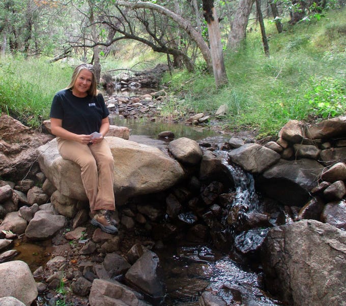
[Laura Norman sitting on a rock structure that has been put in to slow the creek flow]
Alpha: So the USGS got interested in the slow water ideas.
Laura: Well, my project is unique in the USGS. And so I had been looking at ways to develop scenarios that would benefit the people that were living in the Twin Cities of Nogales. And I started modeling different scenarios and got the International Boundary and Water Commission, which is the part of the Department of State, to fund my research to look at the potential of putting those structures in to reduce flooding there in 2010. And then I was at a conference and I saw this fantastic scientist, Ron Pulliam, talking about some structures that he was studying that looked exactly like the gabions we were putting in at Nogales at another location on the border where they were using the gabions to create habitat.
And so it kind of went like that—you know, kind of fell into this new vein of research. And we looked at those structures, and when we looked at those structures, we were looking at the increased vegetation. And we found that where there were structures, there was more water availability, evidenced by increased vegetation or at least maintained vegetation over a 27-year drought period, up to five kilometers downstream from each structure and one kilometer upstream from each structure. And that was really kind of a turning point for me because a lot of people were concerned about structures stealing water from downstream users.
And my research identified in that one scenario—and then many more scenarios—that the structures actually protect the water from being evaporated in our hot and dry desert ecosystem by putting it underground and making more water available downstream to the users. So that was kind of the kickoff to the rest of the research that I've been doing.
Alpha: Oh, cool. Yeah. So you found out from the gabion that it actually caused water to go into aquifers and then come up again further downstream. Is that right? And then you—who proposed to the USGS to do this kind of gabion slow water idea?
Laura: Well, I proposed it to a couple of different people. The USGS has been supportive of my research since I began working here, but I've also had a lot of outside support from different departments of the Interior and also private funding to do studies to look at these potentials. So, you know, the work at the San Bernardino National Wildlife Refuge, and the Gila-San Bernardino area—some of that was done with the International Boundary and Water Commission. We had some support from the Bureau of Land Management just north of there, and the Fish and Wildlife Service was cooperating with us at that time. So it’s been kind of a grassroots-style effort: developing projects, getting funding to do science—but with the USGS backing.
And, you know, when we do projects at the USGS, we have these standardized protocols and we're mandated to do unbiased science. So we have this rigor that’s associated with our science, which is very useful for adapting across different landscapes.
Alpha: So when you put in the gabions, how far away did the water get impacted? Like, you're shifting the hydrology—does it shift the hydrology at the watershed level? How far would you say the impact goes?
Laura: That’s a good question. I haven’t really found the boundaries of the impacts yet. But I’ve had a couple different studies looking at hydrology—not just flood detention, but actual water provision.
I mentioned the vegetation study that we did in San Bernardino. But we’ve also looked at water volumes. At El Coronado Ranch in the Chiricahua National Forest, we looked at a stream that had been treated with over 2,000 little rock check dams, and compared it to an adjacent watershed with similar climate, elevation, and vegetation. One was much larger than the other, but when we calibrated for size, we found that the watershed treated with structures had reduced peak flows, like the ones we saw in Nogales with the larger gabions—but it also had more water coming out of the system. Twenty-eight percent more volume coming out, which is a really big deal in dryland watersheds.
But what was really interesting was the delayed flow. In addition to having more water, it was coming out three to four weeks longer than in the untreated watershed. So when you asked what the dryland farmers were looking for with the structures, I think extending their growing season was one of the benefits they found.
Alpha: So when you say 28 percent, you’re saying the water gets delayed, the peak goes down, but then it’s coming out three to four weeks later—and that’s the 28 percent?
Laura: It wasn’t just the timing, though—it was the amount of water. So, think of a bare surface like in the watershed without structures—it’s just a bedrock channel. If you throw a glass of water down it, it just rushes down the channel and evaporates quickly. In our area, relative humidity is very low—everything gets sucked out into the air.
When I lived in San Francisco, I’d get out of the shower and my towel would be wet for two days. In Arizona, it’s dry in an hour or two. The atmosphere just pulls moisture away.
But in the channel with structures, water gets held back and tucked into the dirt that’s collected behind those 2,000 structures. We hypothesized that those were forming perched aquifers—little spongy wetlands holding water underground and releasing it slowly.
Alpha: What’s a perched aquifer?
Laura: A perched aquifer is like a small sponge sitting on top of the rocks that form the channel. Later studies—most recently I published a paper on leaky weirs and managed aquifer recharge—showed that what we thought were perched aquifers at El Coronado Ranch might just be alluvial storage created by the structures.
So I’ve gone from thinking it was the vegetation, to thinking it was the rocks, to now thinking: it’s the dirt. It’s that combination—soil, water, and carbon—that forms when sediment gets captured by a structure. That becomes a fertile ground for storing water and growing plants—and it just wouldn’t be there otherwise. Each sponge behind each structure is additional storage.
Alpha: How deep does that go underneath the creek bed?
Laura: It depends. All of our findings are place-based and geology-dependent. If a structure is on bedrock, it might not go that deep. But if you have sediment being deposited, water gets captured and pushed around the structures—what’s called lateral flow—into the banks and even underneath when faults or fractures exist.
So surface aquifers get inundated and start releasing water downstream. And in some cases, water might even seep into deeper groundwater if fractures or springs are there.
Alpha: Cool. So the farmers like this because now they have one more month of water into the dry season?
Laura: Yes. And we also found that areas treated by structures become wetlands—either restored historical wetlands or new ones created by the structures. At all these wetlands, we see earlier greening up in the season. So the extension isn’t just into the fall—it’s also happening in the spring, a month or two earlier. That’s a pretty big deal for the growing season.
Alpha: And how far do these wetlands extend past the riverbanks? How much wider are they?
Laura: I don’t have a specific number yet. We are documenting lateral flow into the banks. We did a vegetation study in the channels annually and now every five years in the overbanks to see how far those impacts go. But as water accumulates, it gets pushed out—laterally, down, and under the structure. When you have a lot of them, you get a chain of pools or wetlands.
Alpha: Is that the natural state of rivers in the past? I talked to Stuart Andrews from Australia—he said that’s the natural state before the water cycle was disrupted: series of ponds like a beaded structure.
Laura: Yeah—what do they call it? A chain of pearls or something. I’ve heard that from the Mulloon Institute. In our region, I’m not totally sure. But most locations we work in—where structures go in—it’s in response to erosion and gullying. These areas used to be more stable but are now degraded. Headcuts just travel upstream, draining the grasslands or shrublands.
Plugging those gullies can recreate what used to be there. In many arroyos, you can see old cobbles and paleochannels—evidence of wetter environments. Then we came along with cattle, roads, groundwater pumping—everything that causes erosion. So restoring it is like maintenance.
Alpha: What’s a paleochannel?
Laura: Historic riverbeds. You can see them in soil layers and even aerial photos—like 1935 photos of the Colorado River, you can see old meanders. But today, many of those are gone because we channelized the rivers for urban development. So part of our goal is to put the “wiggle” back into streams—to slow flows again.
Alpha: And the farmlands—are farmers happy because they can pull water from the river? Or is it also seeping under their land, hydrating their soil?
Laura: Both. Water’s available at the surface—so cattle go to stock ponds, and wildlife shows up. We’ve had scientists put cameras around areas with and without structures—wildlife clearly prefer the structured areas. Bears play in the pools. You see dragonfly larvae that wouldn’t be there otherwise.
But the vegetation benefits too. Ancient farmers probably used both surface and subsurface water.
Alpha: So these ponds—are they forming laterally away from the river?
Laura: Not quite. They’re forming adjacent to the river—just like those Australian pools.
Alpha: And on farmlands adjacent to that—do you think it’s seeping far enough laterally that their land is getting hydrated?
Laura: Yeah. As it flattens out into floodplains—that’s where a lot of desert farming used to occur. Like the Hohokam farmers—we still see their canal systems on the landscape. Connecting rivers to floodplains makes all that surface saturated—so more water available for longer.
Alpha: Cool. So this is kind of amazing—you just put rocks in a river, but it ends up hydrating a much wider area laterally.
Laura: For sure. We’ve also looked at temperature. Around rock structures, you see decreases in temperature after rainfall—held for a few days. Just a couple degrees—but that’s significant when you have thousands of structures. You’re creating microclimates—cooler temperatures, more vegetation, and better resilience.
Alpha: And this helps with flooding too, right? Slows the water so it doesn’t flood downstream?
Laura: Yes. It reduces flood hazards, drought hazards, and food insecurity. It keeps sediment in place—so it improves air and water quality. There’s a lot of ecosystem services tied to rock detention structures.
Alpha: Do you think it reduces wildfire risk, too, because it keeps the floodplain more hydrated?
Laura: Taking a cue from my colleague Emily Fairfax—and her work with Joe Wheaton—yes, I think there’s real potential there...
Alpha: Wow. So the CCC is the Civilian Conservation Corps.Yeah, that was around a long time ago in the U.S. And, uh, so they did stuff like this. Amazing.
Yep. So, yeah, I mean, it does seem to me like using these rocks is a much more, I mean, it's a nature-based solution. It's a much more mild way of, I mean, it seems like it's helping restore the water cycle as opposed to a normal way of building big and bigger reservoirs and then aqueducting the water in, and, uh, you know, like the Colorado River right now is being under threat because we're taking so much water.
So if in Arizona you, there are more of these gabions, you don't need to take as much water from the Colorado River or pipe it in. Maybe not. Yeah. Cause it seems like the farmers could get a month more extra hydration. So yeah, it's kind of amazing. Like this, this kind of solution can help with drought, with floods, wildfire and with getting water to farmers. And yeah. Yeah.
Laura: Yeah. And what's really amazing, you know, I mean, I'm not, I'm a high tech girl, you know, I work in a high tech world, I'm a computer all the time, but this is a really low tech solution, you know, and it's low cost and low, you know, low investment with a lot of benefits, for sure.
Alpha: So it's so amazing. How come you think it's not more known?
Laura: I think there's been a lot of, a lot of misunderstandings about structures. And the biggest is that people think that the structures are stealing water from the downstream user. And that just isn't the case.
So as I'm hoping that as science is able to continue to develop these studies and create these metrics, describing the impacts of structures that more people will be enthused to start using them and that some of the restrictions on permitting can be lifted.
Alpha: Right. Well, I have this metaphor I used to try and explain it. So like if you have a museum and you have people coming in, and so you maybe have this rush of people coming in, like that's like a big storm. And then if there's not that interesting a museum, people will just kind of come out again very quickly, right? But if you have a lot of really interesting exhibits or something, then people may stay for two hours, three hours. And so, and maybe in the past, like no one was coming out in the afternoon, because they'd all gone in in the morning, come out by the morning.
But now you've actually delayed their staying. And so they're actually trickling out all through the afternoon. And so you're still getting the same flows out because people have to leave the museum. So you're not losing the water just by, all you're doing is slowing it down so that the people are staying in the museum longer than they're coming out again. And so, so yeah, so the total water is still, you're not losing the water by building these check downs. Yeah.
Laura: And I would say, in this case, people aren't being evaporated into the sky at the museum, but we do see that that tucking the water into the landscapes behind the structures really helps to keep it around and makes it so that more people come out of the museum than they would if unless they were being evaporated out. Cool.
Alpha: And you've come up, you had a name that I hadn't heard before, NIDS, right, for these kind of structures. What does that stand for?
Laura: Natural Infrastructure and Dryland Streams.
Alpha: And where did that name come from?
Laura: Well, I started working with the, you know, the scientists around the country, some of the beaver scientists and carbon, soil carbon scientists and Michael Pollock and others talking about these different types of structures and everybody's kind of got their own name for them. It's one rock dams or zuni bowls or earthworks or weirs or check dams. And so we wanted to just try to lump the beaver dams and the beaver dam analogs, whether they were leaky weirs or there's a lot of different names. So we just said, let's call them NIDS and include them in the whole category. And because what we're finding is that the impacts of whatever type of structure, as long as they leak, as long as it's a permeable structure, it's not damming the stream, but just slowing the flows. Right.
Alpha: Yeah. Because I guess it does have many origins, like many cultures have discovered them like I know in the Middle East, the Fertile Crescent, they had these gabions and then Peru, they had these slogans. So like, yeah, and they've all kind of, I guess each of these cultures then has its own name. And then there was different groups like Permaculture, which study a lot of these structures and then we named them Earthworks. And so yeah, so now we have tons of names.
It is interesting that it's been rediscovered so many times and maybe the western science of hydrology - in the fifties it was really focused on big dams and big aqueducts, but it seems like in the eighties and nineties, they became more interested in, or it started becoming more interested in nature-based solutions - there's this shift in hydrology to now to these things that we discovered in ancient times.
Laura: Yeah, go figure, huh? Yeah, it is nice though, you know, to be able to get some of it documented and hopefully, you know, then we can make the next step, you know, to changing some of those policies and mindsets so that more structures can be installed.
Alpha: And so there is a whole world of hydrological modeling and groundwater modeling that, you know, all these hydrologists do. How many of them now are starting to look at nids or these kind of slowing, slow, how slow water systems affect the whole hydrology in doing that modeling?
Laura: Well, I don't know of too many in the United States, but there certainly are a lot, you know, in China, people that have been studying the impacts of structures in the Laos Plateau for a long time, often citing that in the Middle East, the sand dams in Africa. So it's just something that is kind of coming back to the United States at this time, but wasn't really forgotten in Mexico or some of these other dryland regions. So yeah, I think more and more are now.
Alpha: And so they're doing this hydrological modeling in China, in the Loess Plateau, where they're slowing. the water. Do you know anything about what they found with this hydrological modeling?
Laura: Similar effects. So we often cite each other. You know, when I get requests to review a paper for a journal, it's often on looking at the impacts of different structures in different locations, and vice versa. And so, you become more and more aware of different people's research in different countries.
Alpha: Okay, cool. And in China, were they doing—was it streamflow slowing or was it other types of slow water stuff?
Laura: Yep, watershed modeling. So, looking at Chinchero-style structures. Looking at hillslopes and putting in structures on the hillslopes to slow flows—a lot of check dams in the riparian areas.
Alpha: And then also, because China had, you know, millions of people evacuate because of certain huge floods, they had this whole sponge city movement. Now, I think many cities are trying to absorb more of the rainfall. And I assume they probably do hydrological modeling when they start to create all these sponge cities in China?
Laura: Yeah, modeling is really useful for planning—trying to predict where to get the biggest bang for the buck. You know, is this structure going to create recharge, or whatever it is you’re putting structures in for—is it to slow flows, arrest gullying, or increase recharge? You can use models to try to predict which areas might be most receptive to putting structures in. I often use models that way.
But also, I use models—if we get measurements out in a watershed, then I can use a model to extrapolate. So, taking the measurement at one site and then kind of folding it out into the rest of the watershed to see what those impacts would be if you put more structures there—or if there were structures there, you could see what that would be at a larger scale.
Alpha: And what about the modeling of the hydrogeology—the aquifers? Because I know it's kind of hard to model the aquifers because it's so complex, how it's seeping and everywhere the rock formations are different. Are people doing that too—to model how much the aquifers are refilling when you put in slow water structures?
Laura: Yes. We're doing a project right now in La Paz, Baja California, looking at the impacts on the groundwater aquifers and using groundwater models. We also use groundwater models to interface with watershed models to look at the surface-to-groundwater interactions—at a project here in the San Pedro River, the Babacomari Ranch.
But what we find in some of those deeper aquifers is you have water that's older, and so it's a little harder to track whether or not there's change in recharge around the structure when the groundwater is not getting recharged for 60 to a thousand years.
So, it’s hard to really get that documented. But we are using our understanding of the geology to look at fractures and conduits to the deeper groundwater. We have a study where we're putting dye behind structures and then looking at the time for that dye to reach a potable supply well downstream. So, we have some studies looking at that. But again, with groundwater, sometimes the age is difficult to monitor.
Alpha: That’s cool that you’re doing that modeling. And then there’s also this effect where trees can bring up the water, right? Hydraulic redistribution—where the tree roots can bring up that aquifer water. And so I guess other people are modeling that too? Like, as you slow the water down to recharge aquifers, actually there’s more water available to the whole ecosystem because plants can bring it up now.
Laura: Yeah, yeah. That ET cycle—that's evapotranspiration. So looking at how plants are using the water and how plants impact the water budget is definitely a focus of our research all over dryland areas.
Because, you know, just looking at the impacts on the climate—I mentioned the shade potential, the fact that when water is in the environment, it’s a little bit cooler. And so, yeah, it’s a very interesting cycle. As you degrade a system—I always think of that snowball effect. You get a gully and it just starts unraveling, the whole system becomes unraveled and it just drains out. But it’s the same for restoration. When you put a structure in, the whole system kind of snowballs back the other way. All the processes kind of work together to roll it back up—to sew it back in. It’s really phenomenal.
Alpha: And this whole water budget idea, right—because I think maybe a lot of listeners may not have heard of this idea of a water budget. But basically, it’s a fundamental concept in hydrology where you have the inputs and the outputs of the water budget, right? So you have the precipitation, and then you have the streamflow, which can be an input but then it can also be an output, and through the aquifers—where it goes down and goes up. So you put all these things into an equation.
Laura: Yeah. People often think of a bathtub. You’ve got the bathtub there, then you have the water coming in—that’s the precipitation—and then you have this much water in your bathtub and that’s your storage. And as the water leaves the bathtub, that’s the change in storage.
And then you have the drain—you have the surface water coming out, you have water going into the earth (into groundwater), you have other water coming out from the ground, and then you have the water leaving with either evaporation or transpiration with plants. So that’s the full cycle in a nutshell.
Alpha: Yeah—in a bathtub. Because sometimes you can kind of forget where the water could come from. I think people sometimes forget that if you recharge the aquifers, you can actually give more water to the plants through that part of the water budget, or through the tree roots bringing it up. It’s kind of a forgotten part.
Laura: I remember when someone first mentioned to me the idea to rehabilitate a spring, I thought—how can you make more water come out of a spring? That doesn’t really make sense. And then I saw that occurring at the San Dimas Experimental Forest, where leaky weirs were put in. An old spring that had kind of dried up had this new bank put in—a new water bank—and the water budget there was increased because of the storage. And so it allowed the spring to recharge and start expressing water into the arroyo again. It’s really fantastic to think about that.
Alpha: And is the term "slow water" in the hydrology world? Is that a term?
Laura: It is now.
Alpha: Okay. And are people—are just very few people studying how slow water affects the whole hydrology system, or is there beginning to be a bit of a movement studying this?
Laura: Yeah, I think more people are interested. We've definitely had people come to us and ask us to look at different projects—“Is this actually changing things?” Most hydrologists understand that if you're slowing the flows, there's more opportunity for infiltration. So it seems kind of common sense for people who have studied water their whole lives.
But then when you put the application in—the real-world application—it kind of marries the professional to the practical. You think, “Oh, this is something we can do ourselves, at the surface.”
Alpha: Yeah, I remember we were in Spain talking to some of the city hydrologists—all the municipal hydrologists. They were getting too much water in the wet season, and then not enough for the people—there were water shortages, and even they had to turn off the taps in the dry season. And so their problem was moving the water from the wet season to the dry season. And I was with some of these more water cycle restoration people, and we’re like—well, you can actually slow the water, you know, with stuff like check dams and all this. But it seemed like the municipal hydrologists weren’t aware of these techniques.
Laura: Yeah, it’s funny. I learned about check dams in relation to erosion control—in my watershed management classes. Taking it to the next level—well, yeah, of course it's going to slow the flows. That’s why it’s controlling the erosion. But yeah, stepping back through the lessons and seeing all of the different impacts.
Alpha: I mean, in some sense, one of the central issues—ever since thousands of years ago in hydraulics—is how do you get the water from the wet season to the dry season?
So that’s kind of the central thing. It’s just that we’ve moved to this dam-aqueduct model—or at least in the ’50s—and we’re moving away a bit from it now. But that became the idea: collect the water from the wet season in the big man-made dams, and then just deliver it through aqueducts. But we've forgotten these more simple, low-tech, natural solutions.
Laura: Yep.
Alpha: Cool. Is there anything else you want to share about your work or this whole...
Laura: No, I’m happy that you're interested, though. Thank you so much.
Alpha: Yeah, cool. Are there future projects that you're looking toward—or the USGS is looking at in this area?
Laura: We’ve had a couple of ideas—talking about the potential for growing specific crops behind structures. Is there a way to increase range production? Is there potential to grow mushrooms or other specific crops behind structures? Can you accelerate it with compost?
We have a couple ideas coming up, but right now, we’re just trying to get some publications out—describing the cienegas and the extended seasons and our research down in Mexico looking at water augmentation. So, getting those wrapped up first.
Alpha: Okay, cool. And if people are interested in finding out more, you have a staff page on the USGS site, right?
Laura: Yeah, the Arid Lands Water Harvesting Study. Or my USGS page.
Alpha: Okay, cool. And are there any papers that you might suggest people look at? I’m sure you’ve written a lot—are there any particular papers that people might want to start with?
Laura: Yeah, that summary paper that introduces the NIDS topic would be a great starting point. We have some beautiful graphics developed by Hartwood Visuals, describing 20 years of papers—20 years of research of my own, but also my colleagues Ellen Wohl, Michael Pollock, Emily Fairfax, Rattan Lal, and Alan Gellis—comparing our research around the western United States looking at different types of structures. So that’s the NIDS – Natural Infrastructure in Dryland Streams paper. Natural Infrastructure in Dryland Streams (NIDS) Can Establish Regenerative Wetland Sinks That Reverse Desertification and Strengthen Climate Resilience. That’s a 2022 paper from Science of the Total Environment.
…..
related articles in this newsletter “Slow Water”, “Beavers, biology and slow water- Brock Dolman”, “Slowing our waters-Erica Gies”
This is a reader supported publication


Share this post